Trails & Routes
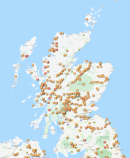
Paddlepoints
PaddlePoints is for paddlers new and experienced. It is free to access without an account, but creating one will allow you to map your own public and private routes. You will also be able to comment on others' points, upload images, store hazards, and create Personal Information Markers to receive updates about new routes and points on your favourite waterways
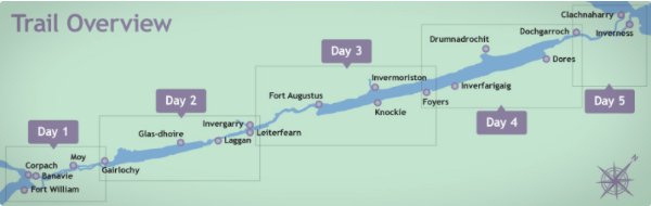
Great Glen Canoe Trail
The Caledonian Canal has brought life to the Great Glen. By opening up the waterway a whole range of industries became possible. The Great Glen Ways offers the outdoor enthusiast three ways to cross the country coast to coast - by boot... by bike... by boat!
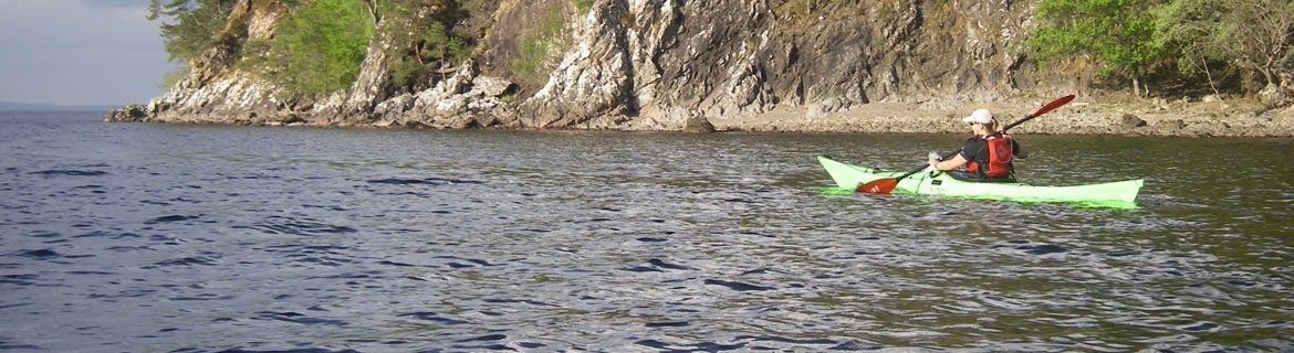
The Great Glen Canoe Trail is yet another example of what adventures await outdoor enthusiasts. With the number of paddlers taking on the Great Glen by boat (canoe and sea kayak), the trail required to be formalised to forward plan and manage both current and future usage.
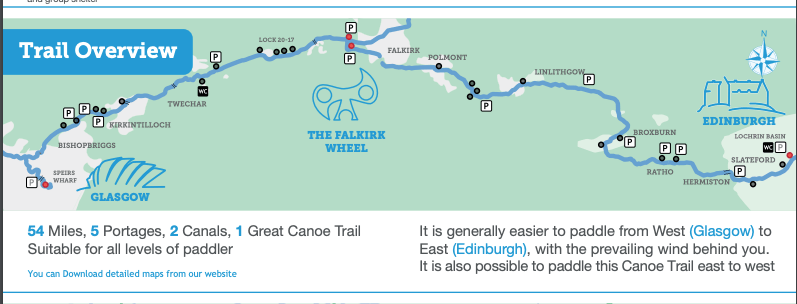
Glasgow to Edinburgh Canoe Trail
This follows the Forth & Clyde and Union Canals, runs through some of Scotland's most densely populated communities. The trail was launched in summer 2014. The 87km trail links the two city centres from Pinkston Basin in North Glasgow to Edinburgh Quay at Fountainbridge, less than 1km from Edinburgh Castle and Princes Street Gardens. It passes through Port Dundas, Falkirk, Polmont, Wester Hailes and Sighthill in Edinburgh.
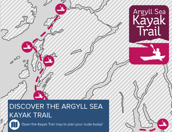
Argyll Sea Kayak Trail
This project was delivered by Argyll and Bute Council and the Oban based social enterprise, Stramash. The Argyll Sea Kayak Trail offers great sea kayaking off the west coast of Scotland. The coastline offers a huge variety of paddling and sights for sea kayakers.
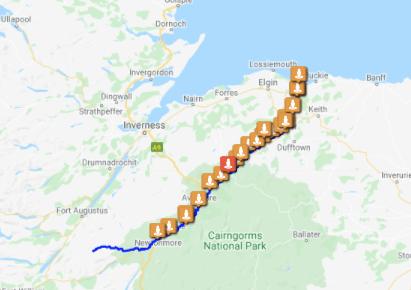
River Spey
A major Grade II/III river that can usually be relied upon to give reasonable water levels in all seasons. Flows past the Cairngorms, through Badenoch and Strathspey and into the Moray Firth at Spey Bay.
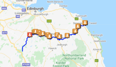
River Tweed
The River Tweed, named after its association with Tweed cloth, is a river that crosses the border between Scotland and England. The river is popular with fisherman due to its salmon-rich waters. If you’re looking for a dramatic countryside paddle, the Tweed can certainly deliver.
River Spey - General Information
OS Maps: Sheets 35, 36 & 28. Also Harveys “Speyside Way” (Waterproof) Map
A major Grade II/III river that can usually be relied upon to give reasonable water levels in all seasons. Flows past the Cairngorms, through Badenoch and Strathspey and into the Moray Firth at Spey Bay.
There is nothing highly technical on the river, however, on sections downstream of Grantown-on-Spey there is a good number of entertaining Grade II rapids.
Popular trout and salmon fishing each day during the season (February to September, No salmon fishing on Sunday).
The river is navigable for most of its length - almost from the source at Loch Spey (where the Spey shares a watershed with the turbulent River Roy). A major hazard occurring just above Laggan Bridge is the Spey Dam, which like the River Roy takes the Spey's waters and takes them westward (this time to help power an aluminium smelter). However, much water and a lot of portage are normally required to make these higher reaches navigable. Although Laggan Bridge is a fairly good access point, Newtonmore is normally recognised as the highest reasonable starting place. Roads run close to the river throughout its length. At all times whilst enjoying this wonderful river, please:
- Park, launch and land with care and consideration at all locations.
- Leave absolutely no litter. If you brought it in, then please, you take it out - and, if practical, that left by other previous less caring, less responsible persons.
- On departure from any camping site no evidence should remain of your being there. Perhaps only the odd temporarily flattened blade of grass. Good guidance is contained in the SCA environment pages.
- Whilst taking statutory, responsible access as per the Land Reform (Scotland) Act 2003, please respect the activities of other river users and residents. Follow the Paddlers' Access Code.
River Spey Canoe Guide 2016.pdf
Other Useful Links
River Spey - Route Description
River Spey - Accommodation and Contacts
Tourism Offices:
Newtonmore 01540 673253
Kingussie 01540 661297 Easter ~ October
Aviemore 01479 810930
Carrbridge 01479 841630 Easter ~ October
Grantown on Spey 01479 872773
Dufftown 01340 820501
Elgin 01343 542666
Canoeist-friendly Accommodation
- Invernahavon Caravan Park, Glentruim, Newtonmore. PH20 1BE 01540 673534 - Kenny and Susie Knox
- Speybridge Camp/Caravan Site, Newtonmore 01540 673275 - Sandy Leslie
- The Beeches (B&B), Station Rd. Newtonmore PH20 1AR 01540 673826 - Jude and Dave Craig davecraig1@btinternet.com
- Newtonmore Independent Hostel, Main Street, Newtonmore. PH20 01540 673360 - Peter and Kathryn Main, pete@HighlandHostel.co.uk
- Strathspey Hostel, Main Street, Newtonmore PH20 01540 673694 - Laurie Skuodas strathspey@newtonmore.com
- The Laird’s Bothy, 68 High Street Kingussie. PH21 1HZ 01540 661334
- Loch Insh Chalets, Kincraig. PH21 1NU 01540651294 - Andrew Freshwater beach@lochinsh.co.uk
- Lagganlia Centre, Feshiebridge, Kincraig. PH21 1NG 01540 651265 - Ian Ross ian@lagganlia.com
- Glen Feshie Hostel, Balacroick, Kincraig. PH21 1NH 01540 651323
- Dalraddy Holiday Park, Dalraddy, Aviemore. 01479 810330 (This site is just 1.2km from the river. Accessible via a rough track leading from the river GR859071)
- Speyside Lodge/Caravan Park, Aviemore PH22 1PX 01479 811688
- Pine Bank Chalets, Aviemore 01479 810000 - Judith and Alex Burns-Smith pinebankchallets@btopenworld.com
- Aviemore Bunkhouse, Aviemore 01479 811181 http://www.aviemore-bunkhouse.com
- Aviemore Youth Hostel, PH22 1PR 01479 810910
- Rothiemurchus Caravan/Camping Park, Coylumbridge PH22 1QU 01479 812800
- Loch Morlich Youth Hostel, Glenmore. PH22 1QY 01479 861238
- Glenmore Camping/Caravan Park, Glenmore. PH22 1QU 01479 861271
- Glenmore Lodge (National Centre) Glenmore. PH22 1QU 01479 861256 info@glenmorelodge.org.uk
- Boat of Garten Camping/Caravan Park, PH24 3BN 01479 831652
- Nethy Station Bunk Houses, Nethybridge 01479 821370 - Patricia and Richard Eccles richard@nethy.org | www.nethy.org
- Abernethy Centre, Nethybridge 01479 82279
- Boat of Balliefurth Campsite (Approx. 3k Downstream of Broomhill Bridge) River right. (Not Balliefurth Farm) Signposted by river ‘Camping This Side’. Please pay at white house 500m along track - Adelaide and Ronnie Macpherson. Booking advised 01479 821435
- Ardenbeg Bunkhouse, Grant Road, Grantown on Spey 01479 872824 - Rebecca Reid. Shuttle service available enquiries@ardenbeg.co.uk
- Grantown-on-Spey Camping/Caravan Park. PH26 3JG 01479 872898
- Cromdale Centre, Cromdale. 01224 208446 - Aberdeen City Council, Leisure Development
- Ballindalloch Station Bunkhouse, Cragganmore 01540 651272 - Andrew Freshwater andy@lochinsh.com
- Ballindalloch Station small campsite with toilet and car parking, Cragganmore, off A95. Access from river from left bank below bridge and walk across bridge to site or look out river-right for a style (not easily seen from the river) approx. 150m. upstream from metal bridge. Then access across field (kindly agreed by Colin Robertson, the farmer) to gate on south side of field. Please close and securely tie the gate as often cows and a ‘friendly enough’ bull in the field.
- *Blacksboat Station Camping Area. Cold tap only facility available, situated on the recently refurbished, large goods-shed now used as a store by the Speyside Way Ranger Service.
- Aberlour Gardens Caravan/Campsite, Aberlour. AB38 9LD 01340 871586 - Simon and Denice Blades. Shuttles may be available. GR 282433
- *Boat o' Fiddich Park Camping Area, Craigellachie. Camp area is located in Fiddich Park by the car park & public toilets. Designated canoe parking area ~ L-shaped fencing, complete with tethering rings ~ 25 metres north/downstream of the black fishing shelter. Use steps upstream of the fishing shelter to gain access on to the Speyside Way. At top of steps, turn left along the Way; continue 300 metres along the track under the bridge. Camping is on the flat areas beyond the car park and wooden toilet building. When paddling away from this location endeavour to stay river-right until the next rapid. (Please avoid using the litter-bin located by the fishing shelter.)
- Burnside Caravan Site, Fochabers 01343 820511 - D G Christiem, GR 350582 Speyside Way Sites - Moray County Countryside Ranger, Aberlour, Banffshire 01340 881266 way@moray.gov.uk
- Loch Insh Outdoor Centre: offer a shuttle pick up at Spey Bay & overnight parking at Loch Insh Outdoor centre. beach@lochinsh.co.uk I 01540651294
Minibus shuttles, including to/from Spey Bay - Jake Strachan, Grantown 01479 870025, 079211 85088 - small canoe trailer available